Ireland is made for slow, scenic driving, with narrow coastal roads, mountain passes, lake valleys, and village stops that reward travelers who leave time for detours. This plan focuses on road trip experiences rather than a general list of famous places, so each stop is chosen for the drive itself as much as the destination.
Use this article to build a flexible Ireland driving route with practical stops, photo viewpoints, timing advice, and visitor tips. The recommendations stay within Ireland and highlight routes where travelers can pause, walk a short stretch, or enjoy a memorable landscape without turning the trip into a strenuous outdoor adventure.
Slea Head Drive, Dingle Peninsula
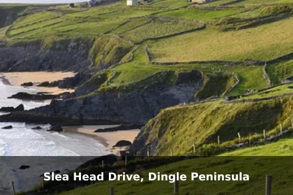
Slea Head Drive is one of Ireland’s most rewarding short coastal loops, tracing the western edge of the Dingle Peninsula where the Atlantic crashes against dramatic cliffs and the Blasket Islands float on the horizon. Its compact length makes it ideal for travelers who want sweeping ocean scenery, ancient Gaelic heritage, and quiet beaches without committing to a full day of driving.
Along the route, visitors can stop at beehive stone huts, the Gallarus Oratory, and Dunbeg Fort, then wander down to Coumeenoole Beach for close-up views of the surf. Frequent pull-offs let you pause for photographs of Dunmore Head, grazing sheep, and patchwork stone walls that define the peninsula’s timeless character.
Travel tip: Drive clockwise from Dingle to follow the common traffic flow and reduce stress on narrow sections.
Best time to visit: Late spring to early autumn, on a weekday morning between 8:00 AM and 11:00 AM.
Ticket price: The scenic drive is free; some heritage stops and parking areas may charge small fees.
Conor Pass, County Kerry
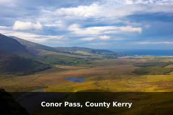
Conor Pass is one of Ireland’s highest drivable mountain roads, a narrow ribbon of tarmac that climbs through the spine of the Dingle Peninsula in County Kerry. The route earns its reputation through sheer drama, threading between sheer rock walls and glacial corries before opening onto sweeping panoramas of Brandon Bay, Dingle Harbour, and a string of dark mountain lakes far below.
At the summit car park, visitors can stretch their legs and walk a short path to a waterfall tumbling from Pedlar’s Lake, with views stretching to the Atlantic on a clear day. Photographers will find layered vistas of patchwork fields, peat bogs, and distant peninsulas, while the descent toward Dingle reveals tight hairpin bends, grazing sheep on the tarmac, and quiet pull-ins perfect for soaking in the silence of the Slieve Mish range.
Travel tip: Avoid large vehicles, check weather before starting, and pull in fully at passing places for oncoming traffic.
Best time to visit: Clear days from May to September, ideally mid-morning after low cloud has lifted.
Ticket price: Free to drive.
Skellig Ring and Kerry Cliffs
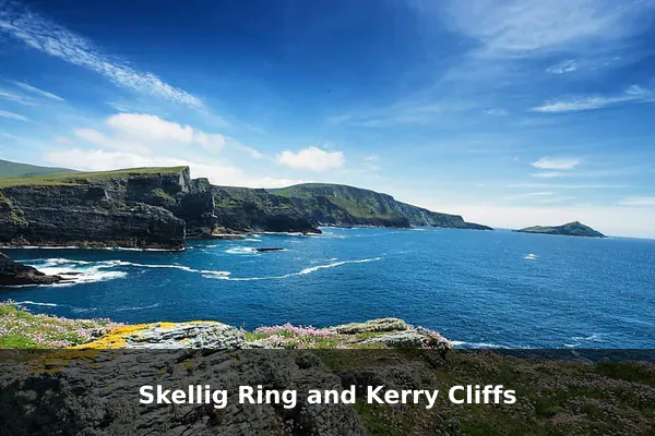
The Skellig Ring offers a quieter, wilder counterpoint to the busier Ring of Kerry, threading narrow lanes through Gaeltacht villages and along some of Ireland’s most dramatic Atlantic coastline. It rewards travelers who prefer space and silence over crowded viewpoints, with the jagged silhouettes of Skellig Michael and Little Skellig rising offshore as a constant, otherworldly companion.
Drivers can pull over at the Kerry Cliffs for sweeping views nearly 300 meters above the ocean, watch gannets and puffins wheel along the headlands, and wander the windswept beaches near Ballinskelligs and St. Finian’s Bay. The route also passes thatched cottages, ancient ogham stones, and the small harbor of Portmagee, where boats depart for the Skellig Islands in calm weather.
Travel tip: Base yourself near Portmagee or Ballinskelligs for an early start before tour traffic reaches the area.
Best time to visit: April to October, with late afternoon best for golden light over the Atlantic.
Ticket price: The route is free; Kerry Cliffs usually charges an entry fee, while prices can vary by season.
Gap of Dunloe Scenic Route
The Gap of Dunloe is one of Ireland’s most dramatic landscapes, a slender glacial pass carved between the Macgillycuddy’s Reeks and the Purple Mountain just west of Killarney. Its combination of mirror-still lakes, weathered stone bridges, and sheer rock walls offers a side of County Kerry that feels untouched, giving road trippers a memorable contrast to the busier stretches of the Ring of Kerry.
Visitors can follow the winding track past Coosaun Lough, Black Lake, and Auger Lake, pausing at the arched Wishing Bridge for classic valley photographs. Many travelers combine a walk or cycle through the Gap with a traditional jaunting car ride and a boat trip across the Lakes of Killarney, spotting red deer, wild goats, and soaring birds of prey along the way.
Travel tip: Park near Kate Kearney's Cottage and explore by walking, cycling, shuttle, or jaunting car instead of driving the tightest sections.
Best time to visit: May to September, early morning or after 4:00 PM for fewer visitors.
Ticket price: Free to enter on foot; bike hire, jaunting cars, boats, and shuttles have prices that vary.
Sheep's Head Peninsula Loop
The Sheep’s Head Peninsula Loop is one of West Cork’s quietest scenic drives, offering a refreshing alternative to the busier Ring of Kerry or Wild Atlantic Way hotspots. Its narrow ribbon of road threads between Bantry Bay and Dunmanus Bay, revealing dramatic sea cliffs, heather-covered hills, and a string of tiny fishing villages where life moves at a slower pace. The peninsula’s remote feel and minimal traffic make it ideal for travelers who want sweeping coastal views without the crowds.
Drivers can pause at Bernie’s Cupán Tae café near the tip of the peninsula before walking the short trail to the Sheep’s Head Lighthouse, which sits above crashing Atlantic surf. Along the way, expect grazing sheep on the road, panoramic pull-offs over Bantry Bay, and quiet harbors like Ahakista and Kilcrohane that are perfect for a slow lunch or a stroll past stone cottages and seaside memorials.
Travel tip: Fuel up before the loop and allow extra time for single-track roads and spontaneous viewpoint stops.
Best time to visit: Late spring through early autumn, especially weekday afternoons in dry weather.
Ticket price: Free to drive; parking is generally free or low-cost depending on the stop.
Healy Pass, Beara Peninsula
Healy Pass is one of Ireland’s most rewarding mountain drives, threading a narrow ribbon of tarmac across the Caha Mountains between County Cork and County Kerry. Its tight hairpin bends and steady climb open onto sweeping panoramas of glacial valleys, stone-walled fields, and the distant glint of Bantry Bay, making it a highlight of any Beara Peninsula road trip.
Drivers can pause at the summit cross near the Cork-Kerry border to take in views stretching toward Glanmore Lake and the Iveragh hills beyond. Along the route, walkers, grazing sheep, and small roadside shrines add character, while photographers will find the switchbacks themselves, curling down the mountainside, to be the most memorable image of the pass.
Travel tip: Use low gears on descents, stop only at safe pull-ins, and do not rush the hairpin bends.
Best time to visit: May to October, on a clear morning or early evening outside peak traffic.
Ticket price: Free to drive.
Sky Road, Clifden
Sky Road is a compact loop just outside Clifden that delivers some of Connemara’s most rewarding coastal scenery in under an hour of driving. The route climbs steadily above Clifden Bay, revealing a layered panorama of scattered islands, sheltered inlets, and the open Atlantic that feels disproportionate to its short length.
Visitors can pull into the marked viewing points to scan the bay for Inishturk and Turbot Island, photograph the ruins of Clifden Castle below the cliffs, and watch fishing boats threading between the headlands. The drive also passes small beaches, grazing Connemara ponies, and quiet pull-offs ideal for a coastal walk before looping back into town.
Travel tip: Take the upper road for the best views, but drive slowly because sections are narrow and exposed.
Best time to visit: April to September, around sunset on a clear day or early morning for lighter traffic.
Ticket price: Free to drive.
Doolough Valley Drive
The Doolough Valley Drive between Louisburgh and Leenane is one of Ireland’s most quietly powerful scenic routes, threading a narrow road between brooding mountains and the glassy waters of Doo Lough. Its haunting atmosphere is deepened by the Famine memorial that marks the tragic 1849 walk, giving every traveler a sense that this landscape carries memory as much as beauty.
Visitors can pull into small lay-bys to photograph the mirrored reflections of Mweelrea and the Sheeffry Hills, pause at the simple stone cross commemorating the Famine victims, and watch sheep drift across the bog land beside the road. The drive is short but deliberately slow, rewarding those who roll down the windows to hear the wind off the lough and the silence between passing cars.
Travel tip: Bring snacks, water, and a charged phone because services are limited along the valley.
Best time to visit: May to September, late morning to early afternoon when visibility is strongest.
Ticket price: Free to drive.
Sally Gap and Wicklow Mountains Drive
Sally Gap and the Wicklow Mountains Drive deliver one of Ireland’s most dramatic upland escapes, all within an hour of Dublin. The narrow Military Road climbs through windswept blanket bog, past glacial valleys and dark reservoirs like Lough Tay, offering a sense of remoteness that feels far removed from the capital’s bustle.
Drivers can pause at unmarked laybys to photograph heather-clad slopes, spot grazing sheep, and take in panoramic views toward Glendalough and the Sugar Loaf. Short walks lead to peat-cut ridges and waterfalls, while the crossroads at Sally Gap itself marks a classic photo stop where four lonely mountain roads meet beneath wide Wicklow skies.
Travel tip: Check road conditions in winter and avoid relying only on mobile signal for navigation in remote stretches.
Best time to visit: April to October, preferably on a weekday morning between 9:00 AM and noon.
Ticket price: Free to drive; some nearby attractions or car parks may charge fees.
Copper Coast Geopark Drive
The Copper Coast Geopark Drive traces a quieter stretch of County Waterford where folded cliffs, sea stacks, and hidden coves tell a 460-million-year geological story. Designated a UNESCO Global Geopark, this route rewards travelers seeking dramatic coastline without the crowds of the Wild Atlantic Way, threading past abandoned 19th-century copper mines that shaped the region’s identity.
Drivers can pull off at sweeping viewpoints above Ballydwane and Kilmurrin Cove, descend wooden steps to tide-pool beaches, and explore the Tankardstown engine houses standing as stark reminders of the mining era. The Geopark Visitor Centre in Bunmahon offers rock and fossil exhibits, while Stradbally Cove provides a sheltered swim spot framed by layered sandstone cliffs and seabird colonies overhead.
Travel tip: Plan short stops at Bunmahon, Stradbally Cove, and Tankardstown, and bring sturdy shoes for uneven coastal paths.
Best time to visit: May to September, during daylight hours and near low tide for beach access.
Ticket price: The route is free; museums, guided experiences, or selected parking areas may charge separately.